Tips from the Trainer: Integrating GPS with GPR
Jonathan Brinkmann, a GSSI Technical Trainer for over 7 years, explains how to use your GPS information with your GPR data. He has also recorded a video that shows the process step-by-step.
Jonathan explains:
“Locating and marking underground utilities real-time in the field has been a powerful application of Ground Penetrating Radar (GPR) for many years. A knowledgeable utility locator with a GPR system as part of their arsenal can skillfully place pin flags and marking paint to accurately identify and designate assets buried underground. This is important information for jobsite personnel like heavy equipment operators and drillers as well as project engineers. But paint marks fade away and pin flags are removed and destroyed over time and the information provided by the utility locator can be lost with these infield designators.
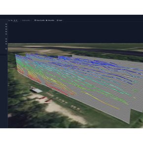
If GPR data is collected with a GPS attached this information does not disappear with the loss of the marks and pin flags in the field. With the GPR data collected, saved, and viewed in a post-processing software it’s possible to identify and “pick” targets and display the results overlaid on Google Earth, or save the information as a Google Earth .KML file or a CAD .DXF file. Here is a video showing how this is accomplished in GSSI’s RADAN7 software.”


