
UtilityScan


UtilityScan
GPR System Optimized for Utility Locating
Locating and marking underground utilities in real-time in the field has been a powerful application of ground penetrating radar (GPR) for many years. A knowledgeable utility locator with a GPR system as part of their toolbox is able to accurately identify buried utilities. UtilityScan is built for the utility locating professional to accelerate workflow from target detection to reporting.
-
Max Depth
10 m (35 ft)
-
Antenna Frequency
350 MHz
-
Weight with Tablet & Battery
16.8 kg (37 lbs)
-
Storage Capacity
512 GB
-
Optional Software
-
Accessories
Geode GPS, Transit case, Model 626 survey cart, Model 656 survey cart
- Scan utilities – metallic and non-metallic
- Locate water lines
- Detect voids and underground storage tanks (USTs)
- Identify soil and foundation characteristics
- Locate shallow objects for archaeology
- 350 HS antenna (350 MHz)
- Panasonic G2 Toughpad
- Lithium-ion battery (2)
- Dual-bay battery charger
- Rugged 2 m ethernet cable
- LineTrac, optional
- Sunshade for G2 Toughbook
- Quick Start Guide
- 2-year warranty


-

Real-Time Target Mapping
Map Mode allows users to trace their steps and gain a bird’s-eye view of their survey. Users can also simultaneously place American Public Water Association (APWA) color-coded marks on 2D data and a geo-referenced map. The on-screen 3D data collection mode allows users to easily define the time slice depth and thickness in the field with the 3D data on the screen. The map window can be minimized to view the 3D display full screen.
-

Integrated Advanced Sensor
UtilityScan can be configured with an optional LineTrac® power detection module. LineTrac is designed to identify and trace the precise location of underground electric and RF-induced utilities. This allows the detected power or induced frequencies data to be overlaid on the radar data, providing reliable positioning and target information to the user. These technologies are integrated into one seamless system to aid in target recognition and mapping, a first for the utility detection industry.
-

Rugged System for Construction Environments
UtilityScan is rated IP65 and built to meet your job site needs. It can withstand the most challenging survey environments including rain, dust, and extreme cold down to -20°C (-4°F). The Panasonic G2 tablet screen is designed for rain and glove use. For areas where Wi-Fi is prohibited, this system includes a rugged Ethernet cable that can be used for communication between the tablet and antenna.


| Display | 10.1” WUXGA 1920 x 1200 Capacitive gloved multi touch + digitizer |
| Environmental Rating | IP65 (tablet dependent) |
| Display Modes | Linescan, Map, 3D and Focus Mode |
| Data Collection Speed | < 3.5 mph (6.5 km/h) |
| Operating Temperature | -20° C to 40° C (-4° F to 104° F) |

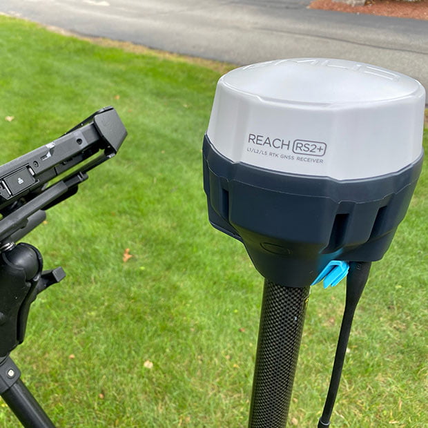
EMLID Reach RS2+
The Reach RS2+ is a survey-grade-capable GPS that operates as a single unit or in base/rover mode with two units. The RS2+ is compatible with UtilityScan, UtilityScan Pro, UtilityScan DF/HS, 200 HS antenna, RoadScan, and PaveScan 2.0.
The Reach RS2+ is a survey-grade-capable GPS that operates as a single unit or in base/rover mode with two units. The RS2+ is compatible with UtilityScan, UtilityScan Pro, UtilityScan DF/HS, 200 HS antenna, RoadScan, and PaveScan 2.0.

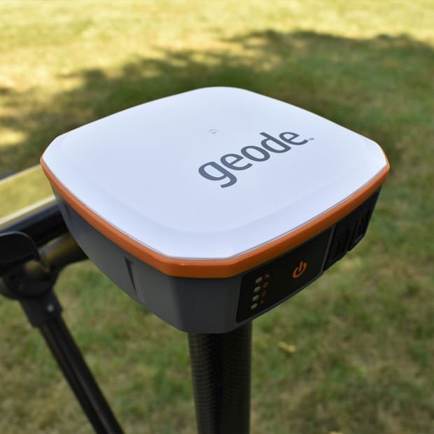
Geode GPS
The Geode GPS is a Multi-GNSS with 9-pin serial port, 1 Hz model. The Geode GPS is compatible with the UtilityScan, PaveScan RDM 2.0 and SIR 4000 based systems.
The Geode GPS is a Multi-GNSS with 9-pin serial port, 1 Hz model. The Geode GPS is compatible with the UtilityScan, PaveScan RDM 2.0 and SIR 4000 based systems.
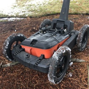
Model 656 Rugged Cart
The Model 656 rugged four-wheel cart is specifically designed for the UtilityScan system. This cart is meant for rugged variable terrain.

The Model 656 rugged four-wheel cart is specifically designed for the UtilityScan system. This cart is meant for rugged variable terrain.

Model 626 3-Wheel Cart
The Model 626 cart is an additional cart option designed for the UtilityScan System. This 3-wheel cart includes a specifically built center positioned bracket to hold the UtilityScan system chassis. The 626 cart is best suited for uneven terrain and grassy field areas.

The Model 626 cart is an additional cart option designed for the UtilityScan System. This 3-wheel cart includes a specifically built center positioned bracket to hold the UtilityScan system chassis.
The 626 cart is best suited for uneven terrain and grassy field areas.
Please provide the following information and we will contact you shortly.
If you prefer, call 603-864-0847. If you need to contact Training, click here.