PaveScan RDM
-
 Imagine
Properly compacted asphalt is a major factor in the lifespan of roads, since inadequately compacted asphalt deteriorates at a more rapid rate than properly compacted material. With the billions spent on road construction and repairs each year, it has become a matter of urgency to find new technologies that can ensure the integrity of asphalt on newly paved roads. What technologies exist for nondestructive pavement testing?
-
 Investigate Phase I
The primary method for nondestructive testing is using a nuclear density gauge, which consists of a radiation source that emits a cloud of particles and a sensor that counts the received particles that are either reflected by the test material or pass through it. By calculating the percentage of particles that return to the sensor, the gauge can be calibrated to measure the density and inner structure of the test material. The two key disadvantages are; that the statistically randomized spot checks don’t account for full coverage data, and the radioactive material is difficult to maintain and store.
-
 Investigate Phase II
In the late 1990’s, Texas Transportation Institute (TTI) discovered the relationship between dielectic calculated by Ground Penetrating Radar and void content as an alternative method to test new pavement quality. In 2013, TTI started working with GSSI, as part of a SHRP 2 research initiative, to further evaluate the technology and to create a commercial package.
-
 Implement I
The PaveScan RDM uses surface penetrating RADAR (radio detection and ranging) to transmit and receive high frequency electromagnetic waves. A tiny pulse of radio-frequency energy is sent out using one or more sensors. This wave reaches the surface of the asphalt and is reflected back to the receiver sensor as a high frequency, electromagnetic reflection. The PaveScan RDM sensors record most of the energy arriving between 1 to 4 GHz.
-
 Implement Phase II
Asphalt density variations create varying reflections that are picked up by the system. An integrated computer records the strength and time corresponding to the return of the reflected signals. The reflected signals are used to calculate the relative permittivity of the asphalt at the location of the reflection using Fresnel’s reflection equations. The relative permittivity values can then be converted to percent void content after calibrating the system using compaction data derived from cores obtained at locations where the relative permittivity was previously measured.
-
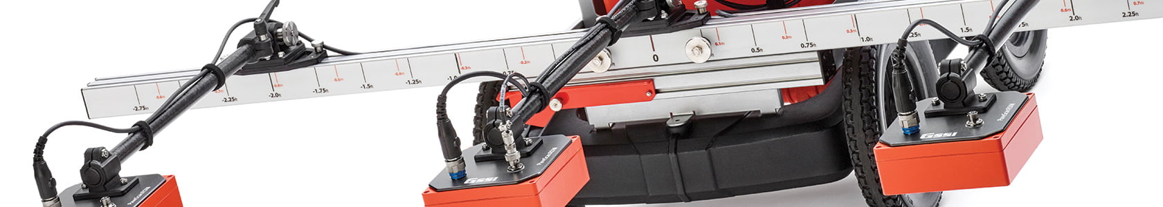
 Impact
In 2016, the PaveScan RDM became available for sale, and is used by industry-leading Departments of Transportation and universities. PaveScan features a flexible, modular design that facilitates easy and efficient operation and data collection. It is available as a small, portable single sensor cart-based system or a three-sensor configuration using an extended cart or vehicle configuration. The entire system is composed of a survey cart, one to three sensors, a customized Panasonic ToughBook, a concentrator box and a variety of system accessories.